
Mobility
We are developing next-generation technology for achieving freedom and safety in movement.
Utilizing AI in “global monitoring of the Earth” and “smart mobility”
After the time of motorization in the 20th century, human beings are searching for new forms of mobility with more “freedom and safety”. To this end, we build a multiscale framework to integrate all the geospatial information collected by diverse mobile agents, such as Earth-observing satellites, aircraft, drones, and the self-driving cars/robots. The raw geospatial data will be converted into semantic maps to support efficient navigation of the mobile agents. In this field, there are the two main research areas, i.e., “global monitoring of the Earth” and “smart mobility.”
In this field, technology is being developed in which machine learning is used to detect terrestrial features accurately from satellite images, as well as technology for automatically creating 3D maps using roving automobiles and autonomous mobile robots.
【1】Global monitoring of the Earth
The innovative downsizing of Earth-observing satellites has realized “constellations” consisting of hundreds of micro-satellites. The resulting huge amount of Earth imagery must be automatically analyzed by AI instead of human eyes. In order to promote the commercialization, we are developing an intelligent system which efficiently collect beneficial information from the tremendous satellite imagery by automatic detection of any kinds of objects and events on the Earth.【2】Smart mobility
While self-driving car technology advances, coexistence with human drivers requires more “human-like” understanding of the surrounding situations. Self-driving agents must grasp accurate geospatial context in real-time through semantic mapping of their total environment. Research is being conducted to support their autonomous guidance and control by constructing dynamic 3D map.In this field, technology is being developed in which machine learning is used to detect terrestrial features accurately from satellite images, as well as technology for automatically creating 3D maps using roving automobiles and autonomous mobile robots.
-
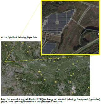
Theme1Automatic detection of terrestrial features using satellite images
Using machine learning and deep learning technologies, huge amounts of imagery received from Earth-observing satellites are analyzed in a fully automatic way. Not only will this enable specific features, such as solar power plants, to be identified, it can also help in detecting and understanding general changes from long-term satellite observations. -
-
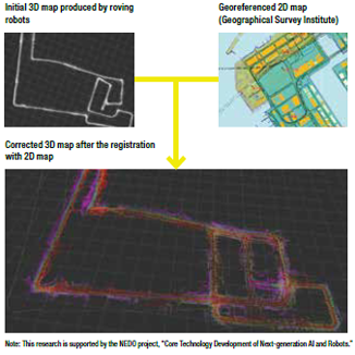
Theme2Automated 3D map generation from roving automobiles
New automated 3D map generation method is being developed that makes geometric registration of new observation points with the reference 2D map. This technology reduces accumulated “distortions” in measurement data, thereby producing more accurate 3D map. This is expected to be utilized for the commercialization of self-moving agents. -
Future prospects
- Development of the mixed-reality platform in which spatio-temporal structures of physical space is authentically transported to virtual cyber space
- Movement prediction of surrounding agents equipped in self-driving cars